Banff based Landscape, Adventure & Ski Photographer.
AL-3.jpg

Road Trip Blogs

A comprehensive guide to road tripping the USA from Banff, Canada.

10 States 🇺🇸

30 Days 📅

8000 km 🚌

11 National Parks 🏕

And a whole lot of amazing experiences! 🤙🏽

🇺🇸 USA 🇺🇸

Nova Scotia & Cape Breton
Cape Breton Coast.jpg

Road tripping nova scotia & cape breton

In the Fall (Autumn for us English folk) of 2018 we finally boarded a plane and took our first trip out East to Nova Scotia. After researching and reading about the area for months, it felt so good to finally head out there. This was mine and Amy’s first ever flight together; along with our rabbit Maggie, who joined us for the road trip…we were pumped to say the least!

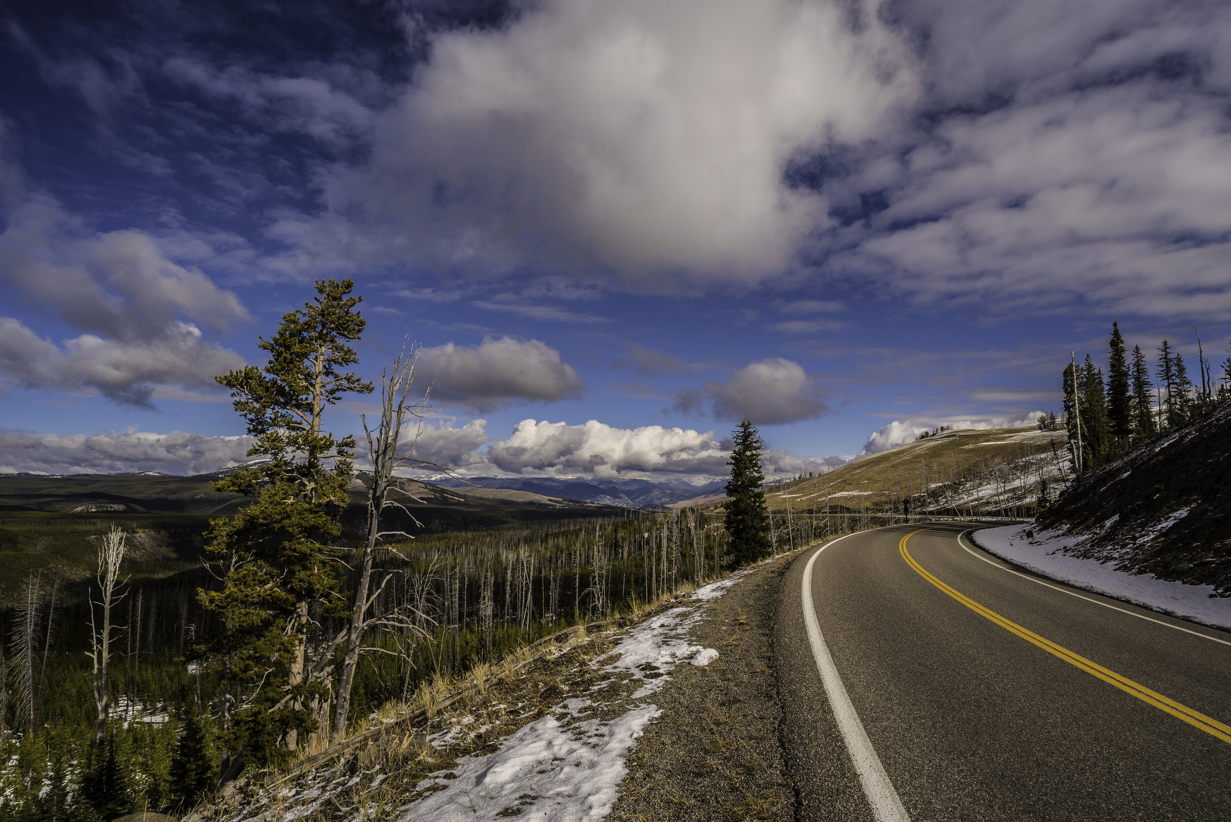
Voted the #1 Island in North America, Cape Breton covers the eastern tip of Nova Scotia. With strong ties to celtic heritage, this rugged coastal region offers the perfect place to immerse yourself in the seasons. We visited in late October in an attempt to catch the beautiful diversity of trees change into their autumnal coat. We lucked out and saw the full change from lush greens to copper, gold, scarlet and vermillion with its peak of spectrum being along the Cabot Trail on the Northern tip of Cape Breton Island.

Peggys Lighthouse.jpg

Getting To, & Around Nova Scotia

We flew here direct from Calgary (YYC) into Halifax (YHZ), the capital of Nova Scotia. Flights within Canada are actually pretty expensive. We opted for direct returns landing early morning and flying out mid-afternoon, which set us back around $350/PP.

Once we arrived in Halifax, we hired a Jeep Wrangler for 24hr hours (which turned into 48hrs after a mishap with our RV booking). The car hire was great, getting us straight on the road from the airport and ready to explore. 48hrs cost around $220 including fuel.

For the remainder of our trip we organised an RV using rvezy.com. We found this to be far cheaper than the larger rental companies. Here you deal direct with the rental owner, still have full insurance and breakdown cover, as well as lots of extra touches that large companies don’t think about… games, welcome treats, generator to name a few. The rental was for 6 days and cost $800 for unlimited mileage - far cheaper than a rental car and hotel costs. Bear in mind these are built for comfort, not economy. Expect to pay $150 for fuel but the trade off is the freedom of home on wheels - totally worth it in our opinion!

Cabot Trail.jpg

highlights to visit

As a photographer it’s easy to get consumed with purely visiting places to get “the shot” and not fully experiencing a place for its heritage, culture and people. Now I’m not saying that these spots aren’t worth a visit, for sure they are! All I’m trying to achieve with this list are ideas to create a comprehensive Nova Scotia experience. Here goes:

Peggy’s Cove - The iconic coastal lighthouse. Beautiful for both sunrise/sunset. Explore the rock pools and small fishing shacks along the harbour. If you’re here at night, the Arcadian skies will treat you to some stellar constellation displays.

Wolfville/Annapolis Valley - A region jam-packed with character. Vineyards, distilleries, crafts, art and great food. We loved Planter’s Ridge and Lightfoot & Wolfville wineries. Be sure to try the local “Tidal Bay” white blends.

Bay of Fundy - With the World’s highest tidal change, Fundy is rugged and lush. Stop in to Port Williams & dine at the Port Pub to watch the tide rush in whilst you enjoy beautiful local seafood. Hall’s Harbour will offer you a traditional Lobster experience like no other.

FALL COLOURS 2-min.jpg

Halifax Waterfront - A bustling spot down by the harbour hosting some of the best restaurants and bars in the province. Take a walk down along the boardwalk at night for beautiful reflections of city lights and boats. We dined at The Bicycle Thief - an Italian themed seafood specialist. Their seafood stew was to die for!

Cape Breton Highlands National Park - One of Canada's most enchanting places, where the mountains meet the sea. As you hug the coastline, you'll wind through the highlands, where lush, forested river canyons carve into the ancient plateau, edged by rust-coloured cliffs. The best way to explore this region is hiking - I’ll come to that later…

Cabot Trail - Needing no introduction, the 298km scenic drive is world-renowned for the array of fall colours, stunning vistas and celtic influence. Drive this anti-clockwise to get the best views and easy access to pull-out stops.

SW Cape Breton - If you have a rainy day, this region has heaps to offer. Wrap up warm and take a walk on its white sandy beaches near Port Hood, enjoy the craic on the Ceilidh trail, and take a tour/tasting at Glenora Distillery. You won’t be disappointed.

Boardwalk-min.jpg

must do hikes

With such varied scenery in Nova Scotia; taking the time to appreciate the natural beauty on foot is by far the best way to see the island. Here’s our top 5 hikes on the Island and why;

Skyline Trail - The perfect way to enjoy sunset. Wind through an elevated path towards the coast. When you emerge at the viewpoint, you’ll be lost for words.

Franey - 360º views of the entire Clyburn Brook canyon and the Atlantic coastline from Cape Smokey to Ingonish.

Tourbiere Bog - Rise early and go to this spot at dawn to watch gigantic Moose graze amongst the marshes as you weave along the boardwalk loop.

Aspy - If its fall colours you want - do this hike! A blanket of Arcadian forest will blow your mind from the southern viewpoint.

Port Hood - Cobbled beach meets white sand - A lovely stop to take a stroll for sunset. Return through the tussocked sand dunes with a beautiful forested backdrop.

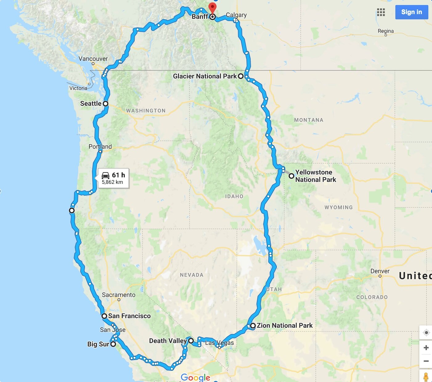
Interactive Trip Map

Below you can find a map of the itinerary. If you click in the top left of the map you will find separate layers marking the destinations, photography spots, hikes and rv spots. To hide and show different layers just click on the check box next to layer’s name. You can also click on the icons on the map to see key info for the places I have marked .  

🚌 Road Trippin’ the USA 🚌 - PREVIEW
Monty Sunset-min.jpg

The Ultimate USA Road Trip

Words & Imagery by Will Lambert

Road trips are the equivalent of human wings. Ask me to go on one, anywhere. We’ll stop in every small town and learn the history and stories, feel the ground and capture the spirit. Then, we’ll turn it into our own story that will live inside our history to carry with us always. Because stories are more important than things.
— Victoria Erickson
Veronica.jpg

WHERE DO I START?!

I’ve been living in Banff now since 2016. I moved here planning on staying 6 months whilst working for a British ski tour operator - Crystal Ski. That one Winter season quickly snowballed into living full time in Canada as a Permanent Resident.

After an arduous 7 months of Winter, everyone can’t wait to get out and explore the local area. Whether it’s hiking, biking, canoeing, or road-tripping… getting outside and making the most of our short Summer season is a must!

One way to maximise this time and avoid the clutches of Winter and it’s -30ºc temperatures is to buy a car and hit the road with your pals. If you’re here on a IEC visa then chances are you have 1 or 2 years (which sounds like a lot) to cram in all those adventures. But what if I told you that you’ll still be skiing at the end of May, and the chances are it’ll be bitterly cold and snowy in October? This only gives you a short period of 4 months to do all these trips to places you’ve read about.

This guide aims to help take the leg work out it for you, breaking down basics like costs, logistics, time-scales; as well as all those must see spots, hikes, dining and more...

A rough idea of the route from Banff around the Western states of America. Full route options shown below.

A rough idea of the route from Banff around the Western states of America. Full route options shown below.

Sunset Views.jpg

BUYING A VEHICLE.

In Banff, car and vans have been circulating the area for years - be warned! Check out vehicles on Kijiji, FB Marketplace, as well as Banff Buy&Sell pages. Look at buying in the Spring when there’s more choice - you’ll be less likely to jump in at the first one you see that way. Buy smart - get a full inspection done at a local mechanic before you buy so you know what your getting into. Expect to pay around $2000 for your average van like our 2002 Pontiac Montana, which sounds like a lot but is the going rate in the valley . Allow for at least $1000 for repairs to get it road-worthy - Winter’s are hard on cars in Alberta. Offer to split the costs with the seller as a way to reduce your costs. Make sure you get a bill of sale and both parties get a copy - you’ll need this for registration & insurance.

Icefields Monty.jpg

INSURANCE ETC.

As a British couple with no previous driving history in Canada, we found Wawanesa to be the cheapest insurer at around $150/month through Rocky Mountain Agencies as our broker and found the process pretty smooth. I’ve heard other people do it through CIBC bank and get very good rates too. Once insured, take your proof of this, plus your bill of sale to Banff Registry to choose your plate - $85 for 1 year. If you haven’t already, they may ask you to transfer your license into a Canadian one - this costs $21 for 1 year or $37 for 2. You’ll need proof of an alberta address and your work permit to do this so bring these too. Last but not least, don’t forget to purchase roadside assistance. We’ve used our Canadian Tire Gold plan a couple of times and it’s worth its weight! Piece of mind and support in a sticky situation throughout Canada & the US will be worth spending $100/year for. AMA also offer competitive rates.

Amy Van.jpg

KITTING OUT YOUR VAN.

Often people will sell vans, ‘camping-ready’ with makeshift beds built in the back and storage crates for all your gear. This is a great way to start if your not the handy type or short on time. In our first van, we had a very basic bed that I built from wood scraps in an afternoon. This did the job for 3 weeks on the road.

In comparison, I had the luxury of time on my side when converting our second van, and spent 4 months over Winter creating a little home on wheels with my partner Amy. The conversion cost us around $600 due to all the materials being reclaimed from Banff’s ReUseIt Centre. You can check out a full series of the van build on my instagram here.

Sandwich Making.jpg

PACKING LIST.

Making sure you have everything you need for life on the road will make the experience all that more enjoyable! Here’s a collection of essential items we’ve used over the last couple of years on our road trips:

🍴KITCHEN: 2 burner propane stove · 12v electric cooler · 2 Pots & 2 Pans (1 large/1 small) · Stove Kettle · Insulated Coffee Mugs · Chopping board · 2 Knives (1 large/1 small serrated) · Can opener · Wine opener · French press · Silicone spatula · Tongs, slotted spoon & fish slice · Lighter & matches · Tupperware · Foil & plastic wrap · Sealable food bags · Spice wheel (MEC) · Washing Up Kit - tub with scrub pads, dish soap & towel · Paper towels · Insulated water container (keeps cool/stops freezing)

🛋 LIVING: Lantern/Torch · Scented candle/air freshener · Bungee cords with hooks · Ikea Bag/garbage bags · Door mat /Shoe Tray · Cards/games · Books · 12v inverter/ charging device · Extra blanket · Bucket · Waterproof bag

⚠️ SAFETY: Jerry can · Breakdown kit - warning triangles, jump leads, spare bulbs, hi-vis jacket, first aid kit · Basic tool kit - screwdriver, hammer, superglue, gorilla tape · Jack & spare wheel kit · Spare Oil/Coolant/Washer Fluid

🗂 ORGANISATION: Milk crates, ‘Rubbermaid’ tubs, IKEA Skubb zipped boxes

Dettah Ice Road.jpg

COSTS.

A road trip can be as back to basics as you like, however it’s likely that a month on the road will cost you more than you might initially think. Here’s a breakdown of rough costs (some may fluctuate - fuel prices - for example):

🏞 American National Parks Access - “America The Beautiful” pass is $80 USD and valid for 1 year. These have two signature spots on them. If you’re lucky, you might find a valid one for sale on Banff Buy&Sell for around $50 CAD - be sure to sign it as most places check it with you ID. Alternatively, park entrance fees vary from $20-40 USD for individual entry. Note that some National monuments (such as Horseshoe Bend, AZ) are on private land and therefore the parks pass won’t work - you’ll have to pay the local entrance fee.

⛽️ Fuel - The cheapest we found fuel was in Montana at $1.95/Gallon USD = 0.67/Litre CAD. On the flip side in California you might pay upwards of $4/Gallon. GasBuddy is a great app that will allow you to search your current location for the cheapest gas prices. Note that some places will only accept credit cards whilst others advertise cheaper prices for cash payment. A 6000 km trip could end up costing over $1000 in gas alone.

⛺️ Camping - This is a big topic which i’ll cover in full next… but for established campgrounds in State Forests for example - expect to pay $35/night.

Winding+Road-min.jpg

WHERE TO SLEEP?

If you’re reading this blog, chances are you’ll be sleeping in your vehicle or a tent. Here’s a selection of ways we find camping spots throughout the US:

🛒 Walmart - Yes, this may not be a glamorous option… but most supercentres will allow you to sleep in the parking lot. You’ll have 24hr access to groceries & washrooms, generally a fast food restaurant attached for food as well as free WIFI if you park close enough to the building. We’ve used these many times in a pinch - especially to break up a long driving day between Montana & Utah for example. Note that some stores have signs saying no parking so check before you snooze!

🏕 State Parks - There’s over 2000 of these throughout the US and most of them operate campgrounds. These are normally $35/night with access to hot showers, dump station, picnic tables, fire pits and barbeques. A great pit stop every few days to grab an all important shower - you’ll need it! They normally operate between the hours of “dawn ‘til dusk” so if you turn up late, just grab an envelope and use the honesty box.

😴 Rest Stops - Along most of the interstates you’ll find rest stops every 50 miles or so. These are basic pull offs right by the highway. Expect road noise and lots of truckers - but if you need a washroom and somewhere to catch 40 winks this is better than nothing.

📱Apps - This is how we find 90% of our sleep spots! Use iOverlander, Park4Night or FreeRoam. iOverlander has given us the most success in North America. Search an area or look directly on the map. Filter your search ‘Wilderness Spots’ to find the free ones. Make sure you snap a photo and leave a review of a site if you find a new place to sleep - it’s a user based platform so sharing info is key!

❗️PLEASE NOTE: Sleeping in parking lots and pull offs in National Parks is prohibited. We’ve been stung by this a couple of times with a knock on the window at 1am by a warden (or a police officer in Zion). You CAN get away with it BUT places like Yosemite are pretty hot on it so plan your sleep spot ahead of time… Book a campsite or drive outside the park at the end of your day - there’s normally places to pull off and sleep in your vehicle without being disturbed. It’ll give you peace of mind and alot less stress in the long run… Trust me!

Bryce+13-min.jpg

WHAT ROUTE SHOULD I TAKE?

Now, I’m writing this as a resident of Banff, Alberta. So naturally the closest route to the states is heading South to Montana - which is a quick 4hr journey from Banff to Carway on the border. This port of entry is open until 11pm, so perfect if you plan to leave after work on a Friday (I know most of you reading this probably don’t work Mon-Fri 9-5 though)! We’ve crossed here more than 5 times and the border agents are always friendly. You’ll have to give in your passports then wait inside whilst the ask you a few questions and process your 90 day ESTA.

From here you’re only an hour or so from Glacier National Park - known for its pristine lakes, rugged glaciers, wildflowers meadows and snow-capped peaks. It’s the perfect place to start your US road trip!

Alternatively, dropping down through Abbortsford/ Sumas port will give you options close by in North Cascades National Park or the city of Seattle. It’s a 10hr journey from Banff, heading West through the Okanagan Valley (which makes an excellent stop over to enjoy some delicious organic produce and some of the best wines made in all of Canada).

Whichever route you choose, you’re going to have plenty of opportunity to explore the Best of the West’, whether that be the West coast of Washington, Oregon & California or go deep into the heart of Wyoming, Utah & Arizona. It all depends on how much time you have! For the purpose of this blog, I’ll give you a guide to a jam-packed 4 weeks loop. You can always cut it shorter to suit your own timescale.

BANFF ➡️ GLACIER ➡️ YELLOWSTONE ➡️ GRAND TETONS ➡️ ARCHES ➡️ BRYCE CANYON ➡️ ZION ➡️ PAGE ➡️ GRAND CANYON ➡️ SEDONA ➡️ VALLEY OF FIRE ➡️ LAS VEGAS ➡️ DEATH VALLEY ➡️ MONO LAKE ➡️ YOSEMITE ➡️ BIG SUR ➡️ SAN FRANCISCO ➡️ REDWOODS ➡️ CRATER LAKE ➡️ OREGON WATERFALL TRAIL ➡️ MT. HOOD ➡️ CANNON BEACH ➡️ MT. RAINER ➡️ OLYMPIC ➡️ MT. BAKER ➡️ NORTH CASCADES ➡️ BANFF

HERE WE GO… Off to montana 🚌

Swift Current Lake - Glacier NP-min.jpg

GLACIER NATIONAL PARK

First of all I’d like to open here by saying that we haven’t had much luck with Glacier over the years! We’ve generally done our road trip in September/ October/ November - which is a beautiful time of year but definitely lends itself to fluctuant weather - Fire & Snow have been our biggest competitors! With that in mind, we’ve only ever visited the Many Glacier area of the park (and brushed the surface at that).

Moose at Swift Current Lake.jpg

MANY GLACIER AREA

This spot is teeming with wildlife and hiking opportunities. Lake Sherburne & Swiftcurrent Lake have proved to be great locations for Moose viewing for us in the past. From Many Glacier campground, we had previously made a list of hikes worth looking in to:

* Grinnell Glacier - 19 km / 483m Elevation Gain

* Cracker Lake - 21km / 488m Elevation Gain

* Iceberg Lake - 15.2km / 381m Elevation Gain

* Ptarmigan Tunnel - 16km / 756m Elevation Gain

* Swiftcurrent Pass - 21.6km / 670m Elevation Gain

* Peigan Pass - 13.5km / 805m Elevation Gain

Check out HikeWithBarry for detailed trip reports!

untitled.jpg

OTHER SPOT IN GLACIER NATIONAL PARK

St Mary is the gateway to the ‘Going to the Sun’ Road, and Lake McDonald.

Famous for its sweeping bends, scenic views & Mountain Goats - this Epic drive is definitely one to add to your list. Once you reach Lake McDonald', you’ll be treated to sparkling open waters and pastel coloured pebbled - perfect for photos and picnics!

Unfortunately we’ve not been able to enjoy much of the park at all so I’m basing much of my writing here on research, rather than personal experience. This is however an important lesson for traveling… things won’t always go to plan and you just have to roll with it, suck it up and be open to change. You’ll often gain new experiences you’d never thought about and have an even better time for it!

I’d recommend visiting in June, July or August to get the best chances of exploring this beautiful National Park in Montana.

NEXT UP…WYOMING 🚌

Fly Fishing.jpg

Yellowstone

National park

Having visited Yellowstone 3 times over the past couple of years from Banff, we’ve gotten to grips with park rather well! In the plan below I’ll detail a two day itinerary, jam-packed with all the best spots, in a logical order similar to that of the “Grand Loop”.

The park itself is a nearly 3,500-sq.-mile wilderness recreation area atop a volcanic hot spot. Mostly in Wyoming, the park spreads into parts of Montana and Idaho too. Yellowstone features dramatic canyons, alpine rivers, lush forests, hot springs and gushing geysers, including its most famous, Old Faithful. It's also home to hundreds of animal species, including bears, wolves, bison, elk and antelope.

Highlights of the trip will include:

* Wildlife Viewing

* Geysers & Hot Pools

* Fall Colours

* View Points & Selfies

You can use the google map above too, and select the Yellowstone map layers to see your driving route, sleep spots and points of interest!

One+Day+in+Zior.jpg
Bison.jpg

DAY 1

Driving: 3 Hours / 147 km

Entering from West Yellowstone on the 191 you’re likely to run into the icon of the park - Bison. In herds of over 50, these giants regularly move between pastures using the park’s road network… be sure to give them plenty of room, drive slow and don’t get too close!

At the first intersection, take a quick detour right and drive the scenic Firehole Canyon road for cascading waterfalls & a swimming hole to cool off in!

Firehole Falls.jpg

Gibbon Falls/Norris

From here follow the route North on 89 stopping in at Gibbon Falls which makes a great spot for some long exposure photography to get soft & silky water.

Next up is the Norris Geyser Basin which is home to a high concentration of acidic geysers including the world’s tallest - Steamboat - which erupts over 90m. Take a wander along the wooden boardwalks to view the geothermal activity and visit Roaring Mountain which appears to hiss and steam as you walk by.

Fort Yellowstone.jpg

Fort Yellowstone

Up on the Northern border of the park is historic Fort Yellowstone. First built in 1891, these ‘cottage style’ homes were built by the General Phillip Sheridan and US army; and were occupied them until 1918 when they were transferred to the National Parks Service. The facilities of Fort Yellowstone now comprise the Yellowstone National Park headquarters, the Horace Albright Visitor Center and parks staff accommodations here in Mammoth Hot Springs. It’s also a great spot to watch elk grazing on the lush lawns of the historic homes.

Nearby is Boiling River - a hydrothermal feature popular for seasonal bathing where a hot spring flows into cold river water.

River+Bend-min.jpg

Tower fall/Calcite springs overlook

Tower falls is a short walk from the roadside and offers a great spot for catching shots of a rainbow in the waterfall!

Calcite Springs Overlook give views out towards the Lamar Valley. The river below is also home to ‘Hoodoos’ - the strange rock formations formed by erosion from the Yellowstone River.

Keep an eye out at Tower Junction… it’s known for being a hot spot of bear activity; Get your camera at the ready!

Bison 2.jpg

Slough Creek Campground

This will be your sleeping spot for the night! 🏕

Nestled amongst wild sage bushes and long grasses, the campground is located up a bumpy track to the North. If you happen to visit in the Fall, then it’s likely that the official campground will be closed. FEAR NOT! On the left, around 50 yards up the rocky path, you’ll find a small pull off - roomy enough for about 6 cars. We stayed here twice and had no issues. There’s even a toilet too. Star gazing is a must as you’re in a natural dark sky preserve!

From here you’re in a great position to explore the Lamar Valley nice and early for optimal wildlife viewing opportunities.

One+Day+in+Zior+2.jpg
Amy%27s+Tree-min.jpg

DAY 2 -

LAMAR VALLEY

Driving: 3.5 Hours / 190 km

BEEP BEEP … 4am Alarm!

Whatever you do, DO NOT SNOOZE! Get up and get on the road. We’ve been here twice and watched as wolves hunted Bison in the pre-dawn mist. As soon as the sun is up in the valley, the animal activity seems to die down. Seeing this makes you feel totally immersed in your personal Discovery Channel adventure!

You won’t be alone either - grab the biggest lens you have, binoculars or telescope (if you’re super keen). Keep an eye out for spotters on the right as you driver along. They’ll have tripods set up and be pointing off into the distance.

Once the day’s rays begin to penetrate the valley though, you’ll be treated to some of the best Fall colours in the entire park. Our favourite of all is this lone Cottonwood - a picture perfect spot, whatever the season.

Artists+View.jpg

Mt. Washburn to Canyon Village & Artist Point

After spending the morning hunting wildlife in Lamar Valley, head back to Tower Junction and take the mountain pass road over to Canyon Village. This route is the highest road in the park and takes you over Dunraven Pass. Here you can stop of for a day hike to Mt. Washburn if you like - watch out for Grizzlies up here! 🐻

Once you reach Canyon Village - stop of for a well-earned bite to eat - the local ice cream parlor is a real treat! 🍦If you need it - Showers/Laundry can be purchased too at the campsite.

Shortly after you’ll reach the turn-off for Artist Point. It’s a short walk from the lot to this stunning view right down the Yellowstone River. The spot is named after Thomas Moran - a famous American painter from the late 1870’s.

A packed lunch stop here could be worth your while as there’s a few picnic spots nearby!

4FF320BE-085B-4079-B201-A1644A8B1F22.JPG

Hayden Valley

Rich with wildlife, the Hayden Valley is a must see on your Yellowstone trip - ensure you have your camera at the ready!

Here we’ve seen Bison, Elk, Bears, Wolves, Coyotes, Bald Eagles, Golden Eagles, Osprey & Pronghorn. For the best chances of viewing… Animals are most active at dawn and dusk. If you’re going early, aim to be in the Valley before sunrise.

Mary Mountain Trail (32km total) also leaves from Hayden Valley and offers anything from a couple of hours stroll in an out amongst the wildflower meadows, to an overnight backpacking experience with great camping opportunities up by Mary Lake. Photographers will love getting off the beaten path here to shoot a variety of subjects - Wildlife, Panoramic Vistas, Flowers etc.

Bottomless+Pool.jpg

West Thumb geysers

A menagerie of steaming geysers, bubbling mud pools, paint pots & the famous Abyss Pool await you at this stop. Use the raised boardwalk to navigate your way around the area.

If you need souvenirs, we found the visitors centre here to have a great selection of patches, postcards and books.

Grand+Prismatic+Spring.jpg

Morning Glory Pool & Grand prismatic Spring

Two of the most famous visual spots to visit in Yellowstone for sure are these two colourful hot springs. The vivid colors in the spring are the result of microbial mats around the edges of the mineral-rich water.

You can visit from the roadside parking lots, or alternatively, take the Fairy Falls trailhead hike to the elevated overlook like the one pictured here. It’ll take around 30 - 40 minutes to reach the viewpoint.

TIP: I’d like to point out that if you get even a remotely clear photograph of either spring, you’ll need to go in Summer when the air temperature is higher so less water vapor is condensing to produce the plumes of steam you see here. Also a day with low wind is a good option.

Old+Faithful.jpg

OLD FAITHFUL Geyser

One of the World’s most famous geysers, Old Faithful was discovered in 1870 by the Washburn Expedition, & was named for its frequent and somewhat predictable eruptions. They number more than a million since Yellowstone became the world’s first national park in 1872.

The geyser erupts around 20 times a day, reaching heights that average 100-180 ft. For up to date information on eruption times, head to the visitors centre close by and check the daily prediction board.

Sunset provides a lovely pastel backdrop for photos and a perfect end to the day. Photographers bare in mind that the salty alkaline water isn’t your gears best friend…bring a good waterproof jacket too… you will get wet!

There’s a couple of stores here for supplies, gas & showers are available at the Old Faithful Inn - which is an awesome log building to visit in its own right!

Monty Sunset-min.jpg

Grant Village

Lake House Restaurant

As we’ve always visited in Fall, the campgrounds have been closed. Whilst this may sound like bad news, it’s not the end of the world. It makes the park a lot quieter for exploring, and makes boondocking much simpler.

Follow Grant Marina Rd. all the way to the large car park by the lake shore. It has a lovely pebble beach, toilets and garbage facilities. We’ve slept here 3 times and had no issues at all. Lovely spot to relax and enjoy sunset after a long day sightseeing.

Morning Mist.jpg

John D. Rockefeller Jr Memorial Highway

As you leave Yellowstone National Park, heading South on the 191 towards Jackson & Grand Teton; you’ll be in for one hell of a treat. This is up there with some of the most beautiful roads in the world.

The Rockefeller Highway was named in remembrance of John D. Rockefeller Jr., a conservationist and philanthropist who was instrumental in the creation and enlargement of numerous national parks including Grand Teton, Virgin Islands, Acadia and the Great Smoky Mountains.

The Snake River flows through the parkway as it heads south to Jackson Lake and is considered a prime trout fly fishing area. The Yellowstone fires of 1988 affected the northern sections of the parkway consuming 4,000 acres. As of 2005, the forest had begun to be rejuvenated and wildlife habitat had actually increased due to better mix of meadow and forest lands.

It’s pretty windy on this stretch of road, so your eyes open for Moose & Bears on thi stretch of highway. Low cloud and fog often hang in the valley at the Northern end of the road too which makes for some atmospheric shots down by the snake river.

Screen Shot 2020-04-27 at 18.15.07.png
Tetons+2.jpg

GRAND TETON

NATIONAL PARK

Grand Teton’s 310,000 acres includes lush valley floors, mountain meadows, alpine lakes and the rising peaks of the Teton Range. While iconic locations like Mormon Row and the Moulton Barns may be the most photographed destinations in the park, Grand Teton’s celestial peaks also provide the perfect setting for nature lovers, outdoor adventurers and road-trippers who are looking to explore the park’s incredible landscapes.

Highlights include:

* Willow Flats Overlook - Pictured here, this viewpoint is a great place to view wildlife. Moose, Elk & Deer often graze on Willow trees below the plateau. It also gives uninterrupted views of Mt. Moran & the Teton range.

* Jackson Lake

* Oxbow Bend

* Jenny Lake Scenic Drive

* Taggart & Bradley Lake Loop Hike

* Moose Scenic Drive

Tetons 5.jpg

Jackson Lake

Take a dip… Cast a line… Paddle… Picnic… the opportunities here are endless.

This 15-mile long glacial lake is located at the base of the Tetons. While it is a natural lake, its size increased significantly with the construction of a damn in the early 1900s. It has since become a recreational destination, with visitors flocking to Jackson Lake's shores for fishing, boating and camping.

Similar to Lake McDonald in Montana - the bed of the lake is a mosaic of coloured stones that render a beautiful patchwork foreground to the mountains beyond, making it a photographers dream.

It has a variety of trails leading from Colter Bay and is a must do on your trip through Grand Teton.

Tetons 3.jpg

OXBow bend

Just after Willow Flats Overlook junction, Oxbow Bend lies on the road to Moran.

This U shaped bend in the river makes for an incredible photography spot any day, but head here at either sunrise or sunset for a pastel coloured sky you’ll never forget.

In the Spring, the body of water becomes the home of migratory waterfowl and birds of prey, making it a must see for birders, photographers & wildlife enthusiast alike!

In the Fall, the banks come to life as Aspen, Birch & Cottonwood trees burst into Autumnal foliage.

Tetons 4.jpg

Jenny Lake Scenic Drive

With numerous lakes and trails to explore, this scenic drive is a one way road that gives access to solitude. It has a seasonal closure to be aware of from November - May.

Take a hike from String Lake up to Leigh Lake and Boulder Island. As these lakes and tributary rivers are sheltered by dense forest, mirror-like conditions can be found which create stunning reflections of the surrounding landscape for any budding photographers.

The open meadows of Timbered Island offer great wildlife viewing opportunities as they graze on the lush grasses and Wild Sage.

Follow this route and take the parking lot on the right just before Beaver Creek. This is the trailhead for Taggart Lake Trail. The trail itself covers 9.7km passing both Taggart & Bradley Lake.

The shores of these lakes are famous for Moose spotting. We came across 3 separate Moose during our hike and a whole lot of poop too! As the path can be quite narrow and the animals do use it for access, be sure to make plenty of noise & carry bear spray just incase!

Tetons+6.jpg

Moose Scenic drive

As the name suggests, the town of Moose and its scenic drive is a real hotspot with a majority of the 800 or so Moose from Grand Teton frequenting the area.

You’ll need a vehicle with high clearance for this road and 4x4 is recommended due to the “potholey” nature of the drive.

Your best chances for Moose spotting are at Dawn or Dusk. These creatures have excellent hearing so be super quiet if you do see them and don’t approach them, especially cows with calves who can be extremely defensive.

If you happen to visit in late September or early October you might be treated to one of the most dramatic displays in nature - The Rut. Bulls dig rutting pits, fight and the victors mate with the females. They also shed the velvet from their racks which looks like something from a horror movie! You may also be lucky enough to hear the males bugling in the dawn silence.